My dad uses Google Maps, and he mentioned that it seems to be getting worse. Like, giving him directions that are obviously worse than alternatives. Has anyone else here experienced this?
Makes sense. Google has been replacing skilled engineers with tail-eating AI regurgitation engines, which are getting progressively worse as they eat their own shit.
But I’ve been told those regurgitation engines are about to get really smart and replace all skilled labor.
So maybe it’ll be fine.
Or maybe, as we’ve already started to see, more and more useful stuff will only be available via the Internet wayback machine, until they kill it.
When AI gets applied to robot bodies, real world results will be able to trim out bad knowledge. Currently because AI only feeds on internet content, all the AI has to eat is human content and AI content.
AI will drift away from accuracy until it gets embodied at which point it will start to get more accurate.
Just have a nuclear reactor to run the LLM on the robot and you’re all set
Real world experience can help, but what we have now is also too stupid to recognize when it’s succeeding or failing. It just greedily gobbles up inputs and feedback indiscriminately.
There’s currently no way to know if the necessary advancement, to advance independently of humans, is 2 years or 2000 years away.
Even so, nature tells us that advancement probably isn’t coming at all. It’s not needed, so long as there are billions of humans available to partner with.
Google/Waze will volunteer users to take alternative routes to scout out ways around congestion. It can be a better route, but you are the guinea pig, so you can get the short end of the stick.
There also is learned driving habits that may inform routing choices.
That’s pretty interesting about the scout cars.Is there any sort of indication thats what they’re doing? I will say given Google’s track record I wouldn’t put it past them to intentionally route traffic near where their paid advertiser’s money comes from.
No indication except for knowing the area and being sent a strange way that doesn’t make sense to you.
The routing is ambivalent to advertising money. The driving data they sell informs where advertisers put money. Horse, then cart; not cart, then horse.
So far… I can easily see some MBA wanting to add that “feature”. They have your driving history, they could easily route someone with Starbucks stops past more Starbucks for a fee.
Yeah, twice this month. It’s taken me through a dirt road (where we got stuck in the mud) and a closed road. Its also told me to turn at places where I cannot or where I must not. I’ve also checked that the car directions are selected and not “bike” or something else.
A few weeks ago I talked with a big truck driver and he said that Google maps sent him through a mud track. At the end the truck got stuck between two village houses. He lost one our to get out with the help of several neighbors. Its time to change to “Organic maps” or Osmand.
I tried organic maps once and it told me to do a u turn as the last instruction in the route, when I actually needed to turn right into my destination. I rarely drive these days but I’ll definitely try it again to see how well it does.
If you see this type of issues you can open a note in OpenStreetMap (register not required). One of the OpenStreetmap volunteers will fix the issue. Take a look at https://wiki.openstreetmap.org/wiki/Notes
Thanks, good to know!
Am from Malaysia and since the road and street is named using local language(bahasa malaysia), google now read out the full road name in terrible accent and pronunciation it took 3 or 4 times longer to finish an instruction readout, which in some case you will miss your turn. The instruction sometime couldn’t even fit on the UI because the road name is just so long. It also read out which lane you should take just for turning. Before the change i can easily navigate the confusing city of Kuala Lumpur because the instruction is clear and concise, now i have to fight with the instruction because 3rd quarter of the time it’s a language i can’t recognise due to the terrible pronunciation.
Ohh did i mention the ads? They found a way to sneak ads into navigation. Now if you want to turn left 500m ahead, instead of telling you “turn left” , they will tell you to turn left after “xyz shop”. Now you will be looking for that shop instead of turn left. The app is maintained by techbros that never drive
You’ve given me flashbacks. I lived in Japan for a few years and occasionally Google would go ahead and read out the street names in Chinese instead of Japanese as though Google maps doesn’t have an exact GPS coordinate for me and thus a pretty good idea of what language those signs should be in. Drove me INSANE. Trying to get around and suddenly my gps is speaking to me in a language I don’t know
I was in New Mexico recently and Google Maps gave me a route from Bandelier National Monument to Santa Fe that included a “shortcut” through the Los Alamos National Laboratory campus. I got to meet a security guard.
So, yes. I would say I have experienced this.
Yes, it is. I use it every day to visit multiple locations. My personal pet peeve is when it displays “In 1.5 miles, continue straight”. On a road where there’s no changes in that distance. That’s not part of the directions, that’s just continuing. Not only is it unhelpful because I can’t not do this “step”, but I can’t see the next, actual step, which could be “In 200 ft, turn left” and won’t know which lane to be in.
I can’t prove it, but I think at some point they applied an automatic algorithm that added intermediate steps to all their routing (for when a road curves a certain way, etc), but it was too aggressive and not human-reviewed.
I do a lot of highway driving. It’ll frequently tell me “in X miles take the exit towards [whatever]” but it will refuse to tell me what exit number I’m looking for until I’m within a mile or two of it. This is frequently a problem when I have exits with A/B/C branches which is often. I don’t give a shit if I’m exiting towards I40, just tell me I’m exiting on 13B, and tell me that from the beginning.
It used to do this, it changed a couple years ago, and I’ve been pissed off about it every time I’ve had to drive somewhere since then.
It’ll also randomly change voices on me, it’ll flip flop constantly between the American accent and a thick British accent. No rhyme or reason to it either, it’ll be a different voice on the same turn on a different day. Drives me nuts.
That’s… some different issues. I think your phone/vehicle/GPS might actually be haunted. Do you know of any exorcists?
There’s a part of a highway near Denver where it’ll tell you to take a “slight right to stay on highway”, and there is literally no possible turn or off ramp there.
Woah, that’s crazy. I was specifically thinking of I-25! Though it does it with other roads and highways as well…
I’ve seen it do that for decades now, and in at least two cases I see it happen is when a highway enters town and gains a name, like how Florida Route 92 becomes International Speedway Boulevard when you enter Daytona Beach. Or, when another route joins the corridor you’re on, like throughout North Carolina US-1, US-15 and US-501 weave in and out of each other a few times along with a few state routes joining and leaving.
So I think when it hits points like this, it sometimes interprets them as intersections rather than junctions, and its programming requires it to issue a direction for an intersection. YOU might not see it as an intersection but IT does.
I don’t need any instructions at all at an intersection unless the instruction is to turn
1: I bet sometimes you do. If you’ve been driving on US-1-15-501, and 1 splits from 15-501, you may ask which highway to keep following. I know of several junctions like that where “go straight” is an ambiguous instruction, especially if one or more lanes just become an “exit.”
2: In many cases I doubt it’s about you. It’s a layered problem.
First of all, you have the United States Highway “system.” 50 state DOTs each doing things their own way with their own goofy ideas and quirks, some roads designed in the 1740s designed by British or Dutch farmers for pedestrians and horses, some roads designed by wildlife that used to walk through the forest that used to be where this town is now and the people put the roads where the tracks were when they put a village in the forest, some roads that are the way they are because they used to follow a railroad that used to be here, some roads designed by people in the 1950s who were going to revolutionize travel for the atomic age, so your nuclear powered car could whisk you down the highway at 190 miles per hour. And every single piece of this for over 3 centuries now has been done as half-assed as possible, each new layer connecting to all the previous layers as an afterthought.
Describe an entire continent of the above fuckeduppery in software please. Oh, and while you’re at it, there’s only 300 million people in the United States, please implement this for Europe, Australia and Southeast Asia while you’re at it in the same software.
And remember, you’re designing this software for EVERYONE. You’re designing a system to be used by my uncle who has a hatred of Sheetz that borders on religious fervor because you order food in there with touch screen menus. You’re designing a system for the idiot who drove into a pond because the GPS told him to “turn left immediately.” You’re designing a system for the professional driver who knows that I-295 is an auxiliary interstate that diverges from I-95 that will eventually rejoin I-95. And you’re designing a system for people who mostly know their home town and could get most of the way there but they haven’t been out to the warehouse district a lot so you’ll have to give them directions from the highway to the UPS distribution center.
Everybody from the iOS native zoomer to my 1960’s uncle uses Google Maps. You can’t design things that make sense to both of these people.
=====
So some drivers will want some information some of the time. So at the city limits of Daytona Beach, your phone will mysteriously tell you to continue straight on State Route 92 because that’s where it stops being called International Speedway Boulevard. Because the non-sentient algorithm deciding when to issue verbal directions often can’t tell the difference between a name change and an intersection of two roads. Or even when it can, it may still offer that change to prevent confusing drivers later, because “Turn left onto International Speedway Boulevard.” 20 minutes later “Continue following State Route 92.” “Wait! I thought I was on ISB! How’d I get on 92? *looks down at phone for 3 entire minutes trying to get the least optimized software in history to scroll the map in a way that makes sense, running over every single toddler in Volusia county in the meanwhile.”
So occasionally it will err on the side of caution and tell you something you might not need to know.
Thank you. I’m not actually that old-school, but back in the day, the only directions that mattered were the changes. “Turn right on the dirt road, and follow it for about 35 miles. Turn right at the crazy magenta and black diner…”
That’s exactly what it is. I just had this happen where two US highways merge, and it told me to “keep straight on HWY 20” at that location. You’ll also often see this where two interstates merge for a while in and around cities.
A bigger problem I have than occasionally hearing “Keep straight on Highway 20” is “Keep straight on US-20, US-94, US-1, US-15, US-501, US-99, US-98, NC-24, NC-27, NC-17, PG-13, PS-5, N-64, I-95, I-85, I-40, Bragg Boulevard for 1.3 miles.”
It puts the instruction at the beginning, and then it talks so long you forgot what it told you to do. It’s how you stack overflow a human.
I’m sorry, I wasn’t paying attention. What were you saying?
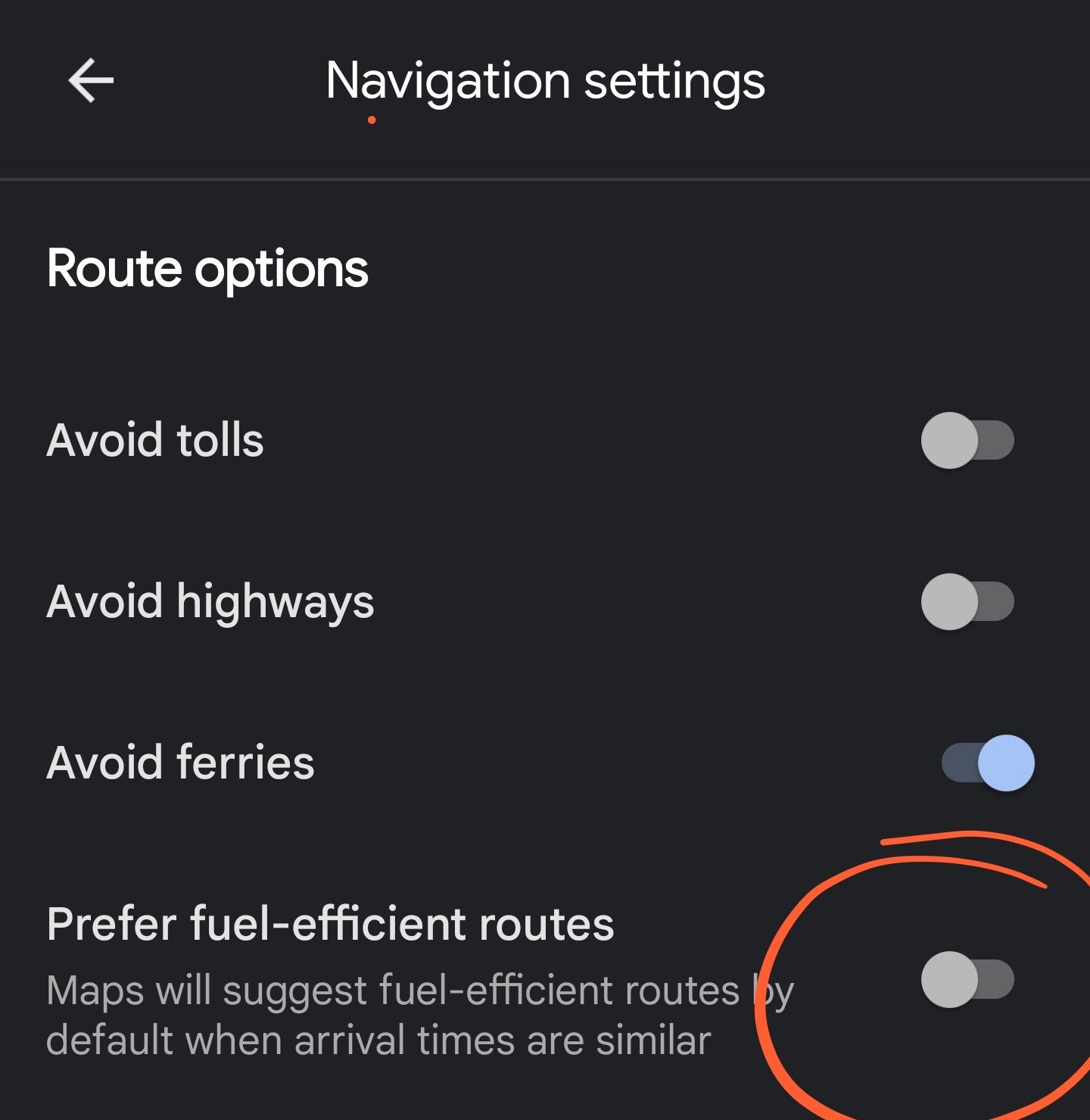
There’s an option to prefer fuel saving routes, which are worse most of the time. This was a kinda recent chance and it is enabled by default, try to disable it and see if it helps

It does indicate the “fuel efficient” route pretty clearly though, and always gives multiple other options including the quickest one that isn’t as efficient. If this is what’s causing the issue, OP just needs to look closer at what’s on their screen.
needs to look closer at what’s on their screen
IT guy here. The number of tickets I could close with this as the root cause.
Honestly I wish you were able to. Some of these people have no excuse to be as ill proficient as they are, and maybe that would change if you could just tell them they ‘read mother fucker’ and let nature take it’s course.
You expect me to READ!? The audacity! 😤
In my experience, the “quickest” are more fuel efficient than the “fuel efficient” routes, which take me through residential areas (where every intersection is protected, meaning a stop sign in at least 1 direction) or stair-stepping on county roads where the speed-up/slow-down cycle negates the benefit of driving on slower roads.
That’s fair, although I think that depends a lot on the type of car you drive. There’s an option to tell Maps what type of car you drive (electric, hybrid, or gas), which will change the results, because cars with regenerative breaking often get better “city” milage than “highway” milage.
It also probably depends on factors like how aerodynamic your vehicle is, because it makes a huge difference above ~50mph (air resistance/drag increases exponentially with speed)
Fun fact, they let you tell them what kind of vehicle you have for the fuel efficient route. So when we told it we have a PHEV, it started recommending more surface streets than highways. Kinda cool.
Interesting. I’ll let him know. Thanks.
Deleted
This isn’t a new thing but I hate anytime it asks me a question. I’ll be driving through an accident scene trying to work out where the cop directing traffic wants me to go and if I’ll need to go a different way because the turn I was gonna make is blocked off and at that precise moment google maps decides it’s a great idea to cover the bottom half of the screen with a “is tHeRe sTiLl An aCcIdEnT hErE?”
If it’s illegal to use your phone while driving it should be illegal for navigation apps to suddenly require interaction in the middle of navigating.
I ignore those types of notices.
It’s definitely been getting worse. The written directions aren’t always accurate. Exits sometimes have the wrong label. Lanes are missing on the highways when they merge and separate.
I’ve also seen a similar thing with routes not always showing up or giving bad directions. It attempted to take me through a school bus barn and even through someone’s yard once.
Yep. Multiple times I have had Google maps direct me to back employee only entrances instead of the regular entrances. Sometimes it seems like Google doesn’t even recognize that the front entrance even exists.
I’d like to recommend ‘Magic Earth’ to everyone, who wants a privacy respecting Maps alternative with trafic data. I used it on several >500km trips and it only misguided me once. It uses OSM maps and can navigate offline.
The only real issue with OpenStreetMaps is that the quality varies significantly town-to-town depending on how much love it’s had by local, knowledgable contributors. Road directions are one of the more complex things to configure in OSM, especially with complex multi-lane junctions, and so densely-populated areas and major roads are likely to be quite good, whereas more rural areas can be hit-and-miss.
Does it give you multiple options for a route? Like fastest/using least petrol/no tolls, etc?
I am currently using Google maps and waze most of the time and tried Organic maps for a while for a more privacy focused option, but it only gives you one option, no alternatives of similar length/time.
Edit: nevermind, just downloaded it and it does offer alternatives. Looking good as well, will definitely test it, thank you!
Seconded! It also has a more informative cycling interface.
You don’t realize a 500km route you take once is shit. It’s when the software sends you on a shit route across town every single day when you measure quality.
I’ve driven the same general route a few times and even then, it has been quite reliable. As mentioned, it can depend on the cities and stuff, so you’re best trying it out for yourself :)
Gonna check that out for a trip next week, thank you!
It coincides with their switch to more and more “AI” black box models. Whereas before they would use a hand-tuned heuristic model to describe whether you are turning, merging, or continuing on a road, they just use a less correct but automagic model where they still inevitably have to tune it a whole lot but it is “AI” so it has the approval of the petty lords of management.
Incorrect entrances and closed roads are another example. They’re just using satellite and street level imagery and tossing it at some models that spit out things like “door 99% confidence” and “road 98% confidence” while neglecting the question of, “are you actually allowed/able to use this?”
PS under basically every correct answer in this category is a team of poorly-paid “labelers” whose answers directly turn into the data in the map. Your door-that-is-not-an-entrance was marked entrance because someone making $8/hr only had 10 seconds to review before moving to the next question.
Semi recently had mine try to take me through a private business parking lot which was entirely fenced off, and didn’t even connect on the other side. That was… confusing, to say the least.
Google Maps is headed by Ray Kurzweil, who refuses to see any downsides to AI.
AI being a great thing is a postulate for this guy.
lmao the futurology grifter
I thought he was head of AI not maps tho
Organic Maps and OsmAnd is better.
My biggest gripe with Organic Street Maps (and every OSM) client that I’ve tried is that I can’t find a way to display the destination address when I get close. I do some delivery work and that drives me crazy. Otherwise, it’s great.
Do you know if either of these incorporate traffic conditions?
as they are privacy focused and have significantly fewer users, not yet.
but, the more users contributing and making requests, the sooner it could be integrated.
you can help by being one of those users!
Thanks for the info!
Does it save route history? Or destinations? That’s one feature I like with Google, disregarding any privacy concerns.
I use OsmAnd+ and you can configure it to save a track every time you use navigation. It can also send that track live to self hosted tracking servers. You need to enable the trip recording plugin.
Ive used those and their routing is not even close to Google maps
Personally, I’ve been seeing way more markers when you zoom in for bigger businesses meaning they are probably going heavy on pay to show.
Not to mention my saved places aren’t permanent markers in the map. I’ll zoom in, still can’t see it. Search for it, oh look, there it is, right where I was zoomed in
Yep, one shape is paid for, the other shape is not (I forget, circles or squares), and to actually see the non paying businesses you have to zoom way in now.
They say it doesn’t affect search
They switched from giving you the fastest route by default to giving you the one that uses the least gas.
They also now offer alternative routes that take you past businesses which paid money to Google.That’s in your trip options “prefer fuel efficient route”. You can turn it off.
I know. But I won’t.
Hypermiling is as fun to me as driving fast is for others.
It’s like a mini-game I get to play every time I’m forced to drive a car.I hypermile casually but I’m not sacrificing travel time to save a bit of gas.
Ahh, I misinterpreted your post as a complaint. I’m not a hypermiler, but I do find the efficient routes are often the lowest stress routes as well.
I hypermile casually but I’m not sacrificing travel time to save a bit of gas.
Elites loves to treat working class time as a zero-value resource. It’s just assumed that everyone is willing to give up hours a week if it means using fewer plastic bags, or less gas, or taking a bus instead of a car, or charging their car during off peak hours, or whatever.
Time is treated as negligible in value.


